Cidades e aldeias sírias despovoadas no conflito árabe-israelense
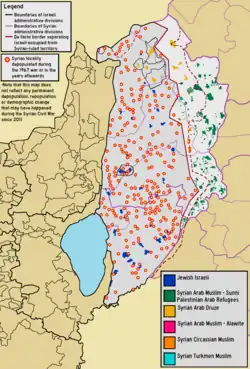
Mapa da localização das localidades sírias cujos residentes foram deslocados desde 1967, sobreposto ao mapa demográfico atual da região.
Antes da Guerra dos Seis Dias e da Guerra do Yom Kippur, as Colinas de Golã compreendiam 312 áreas habitadas, incluindo 2 cidades, 163 aldeias e 108 fazendas.[1] Em 1966, a população síria das Colinas de Golã era estimada em 147.613 pessoas.[2]Israel ocupou cerca de 70% das Colinas de Golã nos estágios finais da Guerra dos Seis Dias.[3] Muitos desses residentes fugiram durante os combates,[4] ou foram expulsos pelo exército israelense,[5][6] e alguns foram evacuados pelo exército sírio.[5] O Washington Report on Middle East Affairs, de 1992, caracterizou as ações de Israel como "limpeza étnica".[7]
Israel expulsou à força os sírios das Colinas de Golã.[8][9] Também houve casos de soldados israelenses matando residentes sírios, inclusive explodindo suas casas com pessoas dentro.[10]
Uma linha de cessar-fogo foi estabelecida e grandes partes da região ficaram sob controle militar israelense, incluindo a cidade de Quneitra, cerca de 139 aldeias e 61 fazendas.[1] Destas, o Censo Populacional de 1967, conduzido pelas Forças de Defesa de Israel, listou apenas oito, incluindo Quneitra.[1] Uma das aldeias habitadas restantes, Shayta, foi parcialmente destruída em 1967 e um posto militar foi construído em seu lugar.[11] Entre 1971 e 1972 foi erradicada, com a população restante transferida à força para Mas'ade, as aldeias povoadas adicionais sob controle israelense.[11][12] A Focaal relata que "95% da população nativa síria foi deslocada à força e apenas cinco aldeias, de um total de 340 aldeias e fazendas, permaneceram."[13]
A Direção Israelense de Levantamento e Supervisão de Demolição das Colinas de Golã propôs a demolição de 127 aldeias desabitadas, com cerca de 90 aldeias abandonadas a serem demolidas logo após 15 de maio de 1968.[14][15] As demolições foram realizadas por empreiteiras contratadas para o trabalho.[6][15][16][17][18][19] Após as demolições, as terras foram entregues a colonos israelenses.[20] Houve um esforço para preservar edifícios de importância arqueológica e edifícios úteis para os assentamentos judaicos planejados.[15]
Após a Guerra do Yom Kippur de 1973, partes das Colinas de Golã ocupadas foram devolvidas ao controle sírio, incluindo Quneitra, que havia mudado de mãos várias vezes durante a guerra. De acordo com um Comitê Especial das Nações Unidas, as forças israelenses destruíram deliberadamente a cidade antes de sua retirada em 1974.[21]
Em 2024, após expandir sua ocupação das Colinas de Golã, Israel tentou despovoar várias aldeias sírias na área recém-ocupada.[22] Depois que os moradores recusaram, Israel começou a destruir as redes de eletricidade e água nas aldeias para tentar expulsar os moradores à força.[22] Em 18 de dezembro, foi relatado que mais de 100 famílias sírias foram expulsas à força das Colinas de Golã pelo exército israelense.[23] As testemunhas relatam que soldados israelenses abriram fogo contra eles e suas casas.[23] As forças de paz das Nações Unidas têm removido bandeiras israelenses na área recém-ocupada.[23]
Cidades e vilarejos despovoados e demolidos
Edifícios destruídos em Quneitra
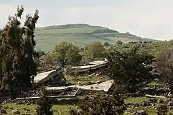
Ruínas em 'Ayn Fit'
Mesquita destruída em Khishniyah
Demolição de uma casa de dois andares em Fiq, 1967
Transferência e deslocamento forçados. Civis sírios, com as mãos erguidas, deixam suas casas nas Colinas de Golã diante de soldados israelenses.
↑Fogelman, Shay (30 de julho de 2010). «The Disinherited». Haaretz.com. Consultado em 15 de agosto de 2024
↑Sulimani & Kletter 2022, pp. 55–56: "Avishay Katz, the commander of reserve Engineer Regiment 602, testified:
At this stage [during the war] the instruction that we have received was to
go and check that no ‘guys’ are left hiding. We did it in the first villages
[conquered] on top of the [Golan] Heights . . . . There were a few cases that
I don’t want to talk about.’
What does it mean? Katz: ‘They killed people that should not have
been killed. Syrian citizens’ . . . There were a few guys of mine who killed
some Arab citizens’ . . .
Why did they kill them? ‘It was out of stupidity, something that should
not have been done, and they were kicked out of the regiment. All the rest
of the Golan dwellers were deported. Not one remained’.
How did it happen? ‘They destroyed a house on top of its dwellers . . .
It was a war crime. . . . It drove me out of my mind’"
↑ abMurphy, Ray; Gannon, Declan (2008). «Changing the Landscape: Israel's Gross Violations of International Law in the Occupied Syrian Golan». Cambridge University Press. Yearbook of International Humanitarian Law. 11: 147
↑Sakr Abu Fakhr, "Voices from the Golan", Journal of Palestine Studies, Vol. 29, No. 4 (Autumn, 2000), University of California Press, p. 7.
↑ abc"The Fate of Abandoned Arab Villages, 1965–1969" by Aron Shai, History & Memory Volume 18, Number 2, Fall/Winter 2006, pp. 86–106. "As the pace of the surveys increased in the West Bank, widespread operations also began on the Golan Heights, which had been captured from Syria during the war (figure 7). Dan Urman, whose official title was Head of Surveying and Demolition Supervision for the Golan Heights, was responsible for this task. Urman submitted a list of 127 villages for demolition to his bosses. … The demolitions were executed by contractors hired for the job. Financial arrangements and coordination with the ILA and the army were recorded in detail. Davidson commissioned surveys and demolition supervision from the IASS [Israel Archaeological Survey Society]. Thus, for example, in a letter dated 15 May 1968, he wrote to Ze'ev Yavin: 'Further to our meeting, this is to inform you that within a few days, we will start demolishing about 90 abandoned villages on the Golan Heights (see attached list)."
↑"The Golan Heights under Israeli Occupation 1967–1981" p.5. "The remainder of 131 agricultural villages and 61 individual farms were wiped off the face of the earth by the Israeli occupation authorities immediately following the Israeli victory in the 1967 war. They were razed to the ground and their lands handed over to exclusive Israeli-Jewish settlement."
Sulimani, Gideon; Kletter, Raz (2022). «Settler-Colonialism and the Diary of an Israeli Settler in the Golan Heights: The Notebooks of Izhaki Gal». Edinburgh University Press. Journal of Holy Land and Palestine Studies. 21 (1). ISSN2054-1988. doi:10.3366/hlps.2022.0283
South Lebanon and Vicinity 1976 – Mapa da Universidade do Texas em Austin, mostrando aldeias sírias nas Colinas de Golã, com base em fontes anteriores a 1967.
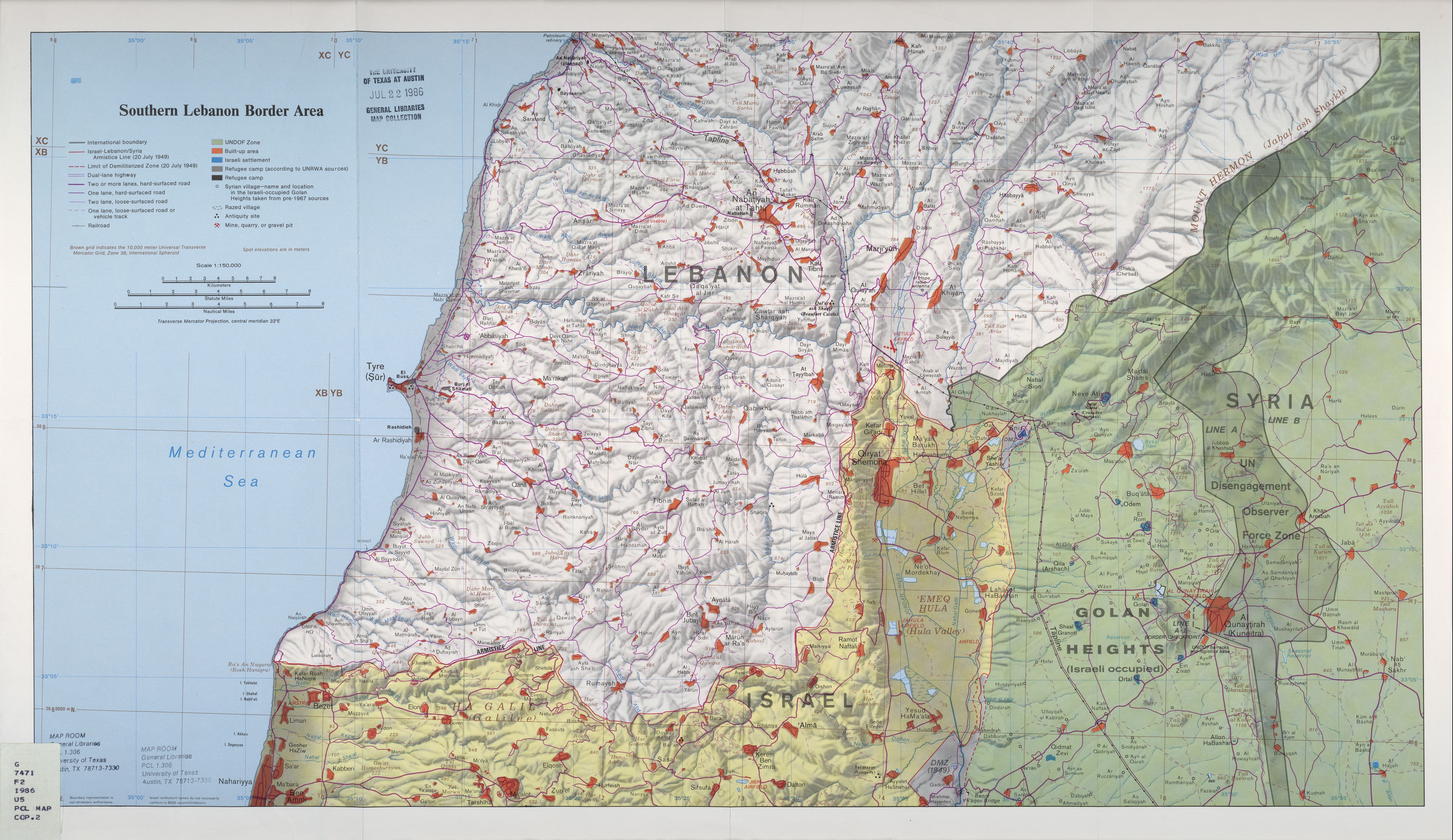
Southern Lebanon Border Area 1986 – Mapa da coleção de mapas das bibliotecas gerais da Universidade do Texas em Austin, mostrando aldeias sírias nas Colinas de Golã, com base em fontes anteriores a 1967.
 Edifícios destruídos em Quneitra
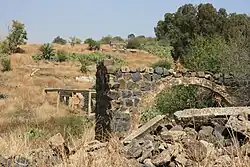 Ruínas em 'Ayn Fit'
 Mesquita destruída em Khishniyah
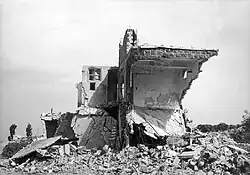 Demolição de uma casa de dois andares em Fiq, 1967
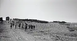 Transferência e deslocamento forçados. Civis sírios, com as mãos erguidas, deixam suas casas nas Colinas de Golã diante de soldados israelenses.
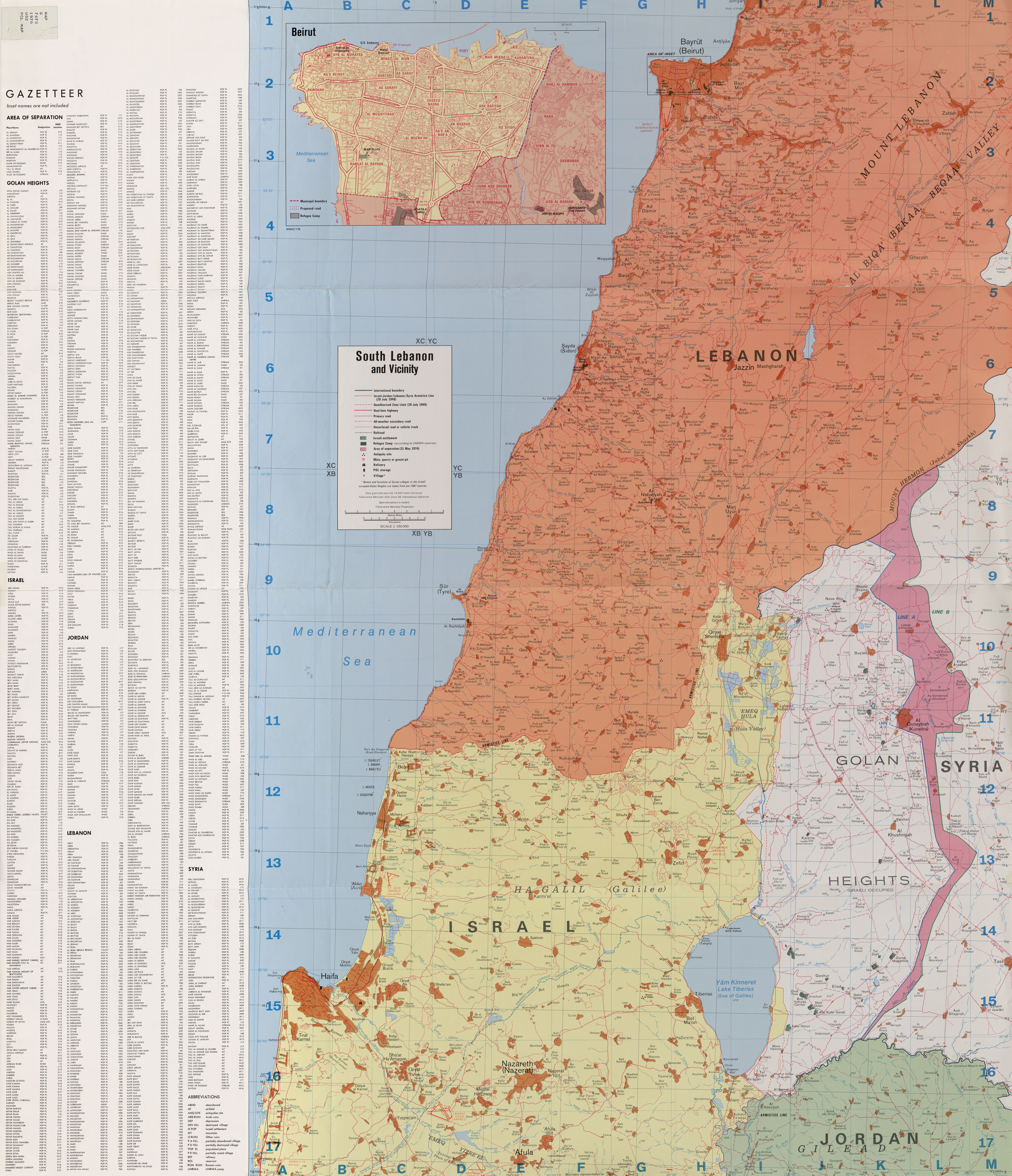