Lista de subdivisões do País de Gales por densidade populacional
Esta é uma lista das Principal Areas por densidade populacional[1].
| Posição | Principal Area | População / km² | |
|---|---|---|---|
| 1 | Cardiff | 4.263 | 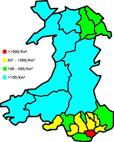
|
| 2 | Newport | 734 | |
| 3 | Torfaen | 717 | |
| 4 | Blaenau Gwent | 631 | |
| 5 | Caerphilly | 614 | |
| 6 | Swansea | 597 | |
| 7 | Rhondda Cynon Taff | 547 | |
| 8 | Bridgend | 530 | |
| 9 | Merthyr Tydfil | 496 | |
| 10 | Vale of Glamorgan | 365 | |
| 11 | Flintshire | 343 | |
| 12 | Neath Port Talbot | 307 | |
| 13 | Wrexham | 261 | |
| 14 | Denbighshire | 113 | |
| 15 | Monmouthshire | 103 | |
| 16 | Conwy | 99 | |
| 17 | Anglesey | 96 | |
| 18 | Carmarthenshire | 74 | |
| 19 | Pembrokeshire | 74 | |
| 20 | Gwynedd | 46 | |
| 21 | Ceredigion | 44 | |
| 22 | Powys | 25 |
Notas e referências
- ↑ Os valores são estimativas do censo de 2007 Arquivado em 2008-10-14 no UK Government Web Archive.